
1. Mt. Balagbag
Mt. Balagbag is a beginner-friendly mountain located in Rodriguez, Rizal (near Manila). It’s easy to reach and so heart-achingly beautiful that it will forever be ingrained in your soul. This is a great place to start if you’re interested in hiking in the Philippines. The mountain trails feature small rivers and waterfalls along the way, making for an extra-enchanting hike.
Mt. Balagbag is elevated 780 meters above sea level. It’s part of the Sierra Madre mountains. The golden grasslands are so wide and open, we bet you’ll be inspired to sit down and write poetry right on the spot. If you happen to hike during sunset, the stunning beauty is kind of stupefying. The spacious, easy layout of Mt. Balagbag makes it a favorite of mountain bikers as well. The trail is so wide, a 4×4 can easily zoom down it.
The only challenge with Mt. Balagbag is hiking under the wide open sky. The mountain seriously lacks trees to shelter you from the sun. It is highly recommended that you hike just before the sun’s peak hours, before sunrise, or before/during sunset.
It only takes about an hour or two to climb Mt. Balagbag. At the summit you will be rewarded with a sprawling view of Metro Manila. If you opt for a night hike, then you will be treated to a view of the city at night, like stars in the ground—very romantic.
How to get there:
- If you are commuting, take a van from Cubao or PhilCoa headed for Tungko. From there, take a jeepney to Licao-Licao, then a tricycle to Sitio Balagbag. The trip will only take you less than two hours from Manila.
- If you are driving a car, just head to Rodriguez, Rizal and then to Brgy. Macabud. An uphill road will lead you to the Licao-Licao area, and from there, you can go straight away to Sitio Balagbag.
2. Mt. Makiling
Mt. Makiling is located in Los Banos, Laguna. This pristine mountain is teeming with abundant flora and fauna: reptiles, birds, and over 2,000 species of plants. This attracts not only mountaineers but scientists as well.
Rising 1,090 meters above sea level, the mountain—which is actually an inactive volcano—bears a famous legend about a mythological guardian and dweller named Maria Makiling (hence the name). If you take a careful look of Mt. Makiling, you will see a “profile” or an outline of a reclining woman— that’s Maria Makiling. The legend has inspired many great literary works – even one by the Philippine national hero Dr. Jose Rizal.
Mt. Makiling is a moderately easy climb. It takes about 4-5 hours to reach the summit, and about 3 hours to descend. A guide is not really necessary as the trails are easy and very much established. The mountain is a favorite destination for mountain climbers, bikers, campers, and even bird-watchers.
The major jump-off point to hike Mt. Makiling is the University of the Philippines Los Banos’ (UPLB) College of Forestry. From there, you will also be treated to several touristy stopovers. One of these is ‘the Mudsprings’: pools of boiling mud in the mountain’s crater that emit a smell of sulfur. These are best avoided if you have asthma, but cool to see otherwise. Be careful not to get too close as the mud can burn your skin. Thick smoke might also emerge from the sulfuric vents.
Other interesting sidetrips at Mt. Makiling include ‘Flatrocks’ (a lovely sight of the river punctuated with slabs of flat rocks), the Makiling Botanical Garden, and The National Arts Center. This is definitely an entertaining spot for anyone wanting to go hiking in the Philippines.
How to get there:
- If you are commuting, take a public bus from Buendia or Cubao headed for Los Baños Crossing. From there, walk to El Danda, which is right beside Robinson’s Mall. Then take the jeepney to Forestry.
- If you are taking a private vehicle, take SLEX to Calamba Exit, then follow the National Highway, then turn right at Los Baños Crosssing. Enter UPLB and College of Forestry.
3. Mt. Batulao
Mt. Batulao is located in Nasugbu, Batangas (just 1 hour from Manila) and it’s perfect for beginners. Rising 811 meters above sea level, the mountain is a painterly illustration of gorgeous landscapes and gently rolling slopes. As you ascend, you will be rewarded with a stunning view of the coastal towns of Nasugbu and Tagaytay.
First-time climbers choose Mt. Batulao because it’s beginner-friendly, but experienced climbers return again and again just for the sheer joy of it. This is a classic destination for hiking in the Philippines.
The jump-off point to Mt. Batulao is KC Hillcrest (Evercret) Golf Course. There are 2 trails: ‘Old’ and ‘New’. If you are hesitant to experience challenges, hiking from the New to the Old trail is your best option as you will barely encounter steep paths. The hike has a few rest stops here and there. The trails are extremely easy to follow so you don’t really need a guide, unless you want to climb at night. If you do want a guide for peace of mind, though, then you and your group may hire one for a reasonable price.
The best time to hike Mt. Batulao is November to February, when temperatures are cooler. Between March and October, prepare for melting heat, unless you start the climb very early in the morning (6 am) to avoid the glaring sun. The ascent takes about an average of 2.5 hours, and the descent 1.5 hours.
When you reach the summit, you will behold a captivating view of the Balayan Bay and 12 surrounding peaks. Be sure you brought a hanky to catch your tears of joy.
How to get there:
- If you are commuting, ride a DLTB bus bound for Nasugbu in Buendia Station. Get off at Evercrest (KC Hillcrest Golf Club), then take a tricycle to get to the registration point. You may opt to walk.
- If you are going there by car, your best option is to head to Tagaytay via Cavitex or SLEX. At the intersection in Olivares, take the path to Nasugbu. Turn left at Evercrest (KC Hillcrest). Take the first right, then drive straight until you reach the parking area.
4. Mt. Tibig
Mt. Tibig is a small mountain found in Lobo, Batangas. At 563 meters above sea level, it’s actually a sub-mountain of Mt. Banoi. Still, it offers a picturesque view of Verde Island Passage, Batangas, and lush green mountains.
Mt. Tibig It is a bit of an exhausting climb—non-stop and zig-zaggy—but it only takes about 2 hours to reach the glorious summit. It’s splendid at sunset. I know, I know – everything looks magical at sunset – but Mt. Tibig is just surreal when splashed with the golden hues of the dying sun.
The climb is a steep assault right from the start. Some paths are dangerous and slippery, so a guide is necessary for physical assistance. On the way to the summit, enjoy sights of grassy peaks, woodlands, limestone rocks, colorful flowers, even farm goats… It’s a very interesting and scenic trail.
If you wish to stay for the night, you can camp right at the summit! The campsite is at the pinnacle of the mountain. It can only accommodate less than 10 tents, though, so let’s just hope it isn’t crowded on your chosen night. Also, fair warning: if the night is windy it can rather be terrifying —it feels like you are caught in the center of a typhoon. And when the winds come with rain, then you better be brave. It’s worth it for this unique experience hiking in the Philippines, though!
If you aren’t ready to head home after experiencing Mt. Tibig’s spectacular view from the top, you can take a sidetrip to Lobo’s Gerthel Beach for a refreshing dip.
How to get there:
- If you are commuting, ride a bus from Cubao or Buendia Station in Manila headed for Batangas. Get off at the Grand Terminal, then from there, take a jeep to Balagtas Proper. Then take another jeep going to Lobo’s jeepney termina and get off the main town. Take a tricycle to Sitio Hulo, Barangay Banalo and get off at the registration site.
- If you are driving a private vehicle, take the SLEX and follow S Luzon Expressway/R-3 and Calabarzon Expresswat to San Jose-Ibaan – Batangas Road in Ibaan. From the Calabarzon Expressway, take the exit toward Ibaan. Drive to San Jose-Ibaan – Batangas Road. Take Taysan – Ibaan Rd and Taysan – Lobo Rd to Jaybanga – Nagtaluntong Road in Lobo. When you get to Lobo, head on to Barangay Banalo.
5. Mt. Maculot
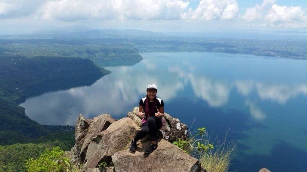
Mt. Maculot is found in Cuenca, Batangas. It’s another favorite of both first-time and experienced hikers. Rising 930 meters above sea level, Mt. Maculot requires a guide due to its steep trail and one challenging section called “Rockies,” which requires actual mountain climbing. It sounds pretty dangerous, but it’s totally safe and thrilling if you are cautious and avoid doing anything crazy.
Upon reaching the summit, which takes about 3 hours, you will be assaulted by the stunning beauty of the Taal Lake. Mt. Maculot offers the best 360-degree view of the glorious lake and the surrounding lush forests.
There’s plenty of vegetation on the mountain, so you won’t be in any danger of heatstroke. Gently swaying trees will shade you from the harsh sun. Your only risk will be withdrawal symptoms once you descend and start to miss the beauty at the top!
Mt. Maculot is also a compellingly mysterious mountain to many superstitious Filipinos, who believe that the mountain is enchanted or cursed. This is said to have caused several deaths in previous years. Hikers are not deterred by this though, and continue to enthusiastically climb Mt. Maculot. Scaling the “Rockies” and taking in the views make Mt. Maculot one of the most places to go hiking in the Philippines.
How to get there:
- If you are commuting, take a bus from Cubao or Buendia that is headed for Batangas. Get off at the Tambo Exit. Then take a jeep to Lemery and get off at Cuenca. From Cuenca, ride a tricycle going to the main jump-off point.
- If you’re going there by a private car, go through SLEX, then proceed to Star Tollway to Batangas, taking the Tambo exit. From the Tambo exit, turn left to Lipa-Tambo H-way all the way to Banay-Banay. Then turn right before the Phoenix Gas Station, then drive straight towards the National H-way that will lead you to the Cuenca town proper. From the market area, take the first right. From there, you may ask the locals for exact directions to the registration site and the mountaineers store.
6. Mt. Pico de Loro / Palay-Palay
Pico de Loro (also known as Mt. Palay-Palay) in Batangas rises 664 meters above sea level and is a rather famous mountain for hikers looking for a weekend getaway. The mountain invites day and night hikers, rewarding them with lush vegetation (it’s part of an Environment and Natural Resources protected area) and paths perfect for trail runners and hikers training for challenges. Pico de Loro is not really for beginners, as the trails are steep and the climb is tedious. Reaching the pinnacle is all worth it, though.
The fun at Pico de Loro doesn’t end at the summit, either. You can go for a more thrilling experience by climbing up Parrot’s Peak, or the Rock Monolith, a 50-foot single pillar of stone protruding from the summit which is the trademark of the mountain. Very instagrammable. The monolith can only accommodate one person, though, and scaling it on a rainy day is a total no-no. But even on a summery day, this famous rock is truly for brave souls. Unfortunately, Parrot’s Peak was recently closed off due to massive loss of vegetation and erosion – so check its status before you go.
Still you can enjoy the summit without the monolith. A selfie with the stunning backdrop of rolling hills, neighboring mountains, passing clouds, and a 360-degree view of the provinces of Cavite and Batangas is sure to make your Instagram followers jealous. The mountain also has diverse flora and fauna. Sometimes it’s a den for bird hunters selling their prey illegally. Be sure to never to buy wild animals, as this will only encourage the poachers.
Pico de Loro has a campsite. It’s littered with nipa huts owned and manned by locals selling convenience items (perfect for those of us scatterbrains who always forget something back at home) and snacks. The goods are pretty expensive, though. The campsite feels like a park. It’s full of hikers hanging out, snacking, chatting, and playing music. From the campsite, it’s only just a 5-minute hike towards the summit. You don’t really need a guide, as the mountain trail is very easy to follow without any risks of getting lost. You may only need a guide if you need physical assistance to traverse the steep assaults.
How to get there:
- From Metro Manila. From the Coastal Mall, take a bus going to Ternate, Cavite. Get off the bus station and take a tricycle to go to the DENR Registration site.
7. Mt. Gulugod Baboy
“Baboy” is the Filipino word for “pig,” and “Galugod” means “spine.” The mountain was thus called because its hills resemble a pig’s spine. You’re also likely to encounter literal pigs during your trek—plus other farm animals. Mt. Galugod Baboy is found in Anilao, Mabini, Batangas. It first gained popularity as a sidetrip for scuba divers, because Anilao is a hot spot for scuba diving. Now it’s well known for hiking in the Philippines.
Mt. Galugod Baboy sits at just 470 meters above sea level. It’s very inviting to adventure-seekers because it has multiple trails and jump-off points, and a compass is often required. The climb is kind of difficult and sometimes slippery, so caution is necessary – and a guide, too. There are resting places, though, to soothe your sore muscles. They’re normally residential or private areas, where you’ll be handed drinks (for a fee).
The mountain has 3 peaks. Once you reach a summit, which will take you about 2 hours tops, the view of the Balayan Bay and the Batangas Bay is intense. The highest peak is the historical Mt. Pinagbanderahan—“bandera” means “flag,” and this is where the Japanese raised their flag when they penetrated the Philippines. The mountain also has a famous tree, desolate amidst the rolling hills. You’ll find it.
How to get there:
- If you are commuting, go to Taft-Buendia, and from there take the bus to Batangas and get off at the Grand Terminal. From there, take a jeep and get off at Mabini, then ride a tricycle to the barangay. Just tell the driver you’re headed for Mt. Gulugod Baboy or Philpan Dive.
8. Mt. Manalmon
Mt. Manalmon is another beginner-friendly mountain found 2-3 hours from Manila. It only takes 40 minutes to 1 hour to reach the summit, so it’s a great mountain for first-timers (or anyone impatient)! Mt. Manalmon is located in San Miguel, Bulacan and rises 196 meters above sea level. The short climb is a charming adventure: to enter the trail, you must go through a cave.
The hike itself is short, but Mt. Manalmon offers other adventures. There’s spelunking and bouldering, and for the bravest souls: Monkey Bridge (a wire tightrope over a river). A normal bridge is also available for the less adventurous. The mountain is part of the historical Biak-na-Bato National Park in San Miguel, Bulacan.
Climbers are attracted to Mt. Manalmon for the charming landscape—serene rivers snaking through lush vegetation and canopies of giant bamboo trees. A campsite sits along the river bank.
Mt. Manalmon actually lies on top of another mountain, Mt. Gola, which is a longer, more challenging hike to the summit. The area is full of some of the best hiking in the Philippines.
How to get there:
- If you are taking a public transportation, go to Cubao, then ride a bus bound for Cabanatuan. Then get off at Brgy. Kamias, San Miguel, Bulacan, then flag a tricycle going to Brgy. Madlum.
- If you are taking a private vehicle, take the Sta. Rita exit from NLEX, passing through Plaridel, Pulilan, Baliuag, San Rafael and San Ildefonso. Just ask directions to get to Brgy. Madlum.
9. Mt. Daraitan
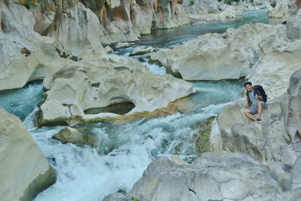
Mt. Daraitan is another adventure mountain found right at the heart of the Sierra Mountain range, near Manila. It’s situated near the borders of Tanay in Rizal and General Naker in Quezon. At Mt. Daraitan you can do more than trekking: you can enjoy seeing caves, natural pools, springs, and limestone formations. There’s even river-rafting!
The white rock boulders and towers of limestone are what attract droves of mountaineers and adventure seekers to Mt. Daraitan. To top it all off, the summit offers an astonishing view of the Sierra Madre mountains. If you are lucky, you may witness a sea of clouds at the peak.
After a serene hike up the mountain, which rises 739 above sea level, you can then enjoy a swim at the crystal waters of Tinipak River, or at the pools of the Tinipak cave. This is hiking in the Philippines at its finest.
How to get there:
- If you are commuting, head to EDSA-Shaw and from there, take a jeep or SUV at the Starmall terminal going to Tanay terminal/wet market). From there, ride a tricycle to Brgy. Daraitan.
10. Mt. Talamita
Mt. Talamitam is a neighbor of Mt. Batulao in Nasugbu, Batangas. The name “Talamitam” comes from the talamitam trees that used to grow on the mountain. The peak is 630 meters above sea level. It features rich cogon grass, but these days there are barely any trees to shelter you on the trail to the summit. Choose your hiking time wisely to avoid the sun.
Mt. Talamitim is mostly flat terrain, so the hike itself is easy. The trek to the peak takes about 1.5-2.5 hours and leads you through a forest and a grassland. In the forest you will have to cross a river by a makeshift bamboo bridge. The descent on the other side of the peak is difficult and leads down to the Talimitam river.
At the summit, enjoy a glorious view of the towns of Calatagan and Nasugbu, plus the Marogondon hills and mountains. You can also catch sight of other various mountains, like the Pico de Loro, Mt. Batulao, Mt. Marami, the Taal Lake, and the Lubang islands. Also at the peak, barn swallows will accompany you, which pretty much feels like a scene from a fairy tale! But it’s no fairy tale, just another day hiking in the Philippines.
Descending Mt. Talamitam does not end your adventure, though. If you wish, you may take a side trip at the mountain’s foothills for a swim in the relaxing waters of Layong Bato, or Layong Bilog—which is a part of the Galo River. Be careful, though—to reach this hidden gem you have to cross through Galo’s rocky riverbanks, which is pretty slippery.
How to get there:
- To commute there is astonishingly easy—just one bus ride (2.5 hours) from Coastal Mall!
- If you are driving, head to to Tagaytay either via SLEX-ETON Greenfield -Sta. Rosa— or via Cavite. Drive all the way to Batangas until you reach KM. 83. Make a right turn at the small side street past the school and look for parking space. The jump-off point to trek Mt. Talamitam is at Sitio Bayabasan, Brgy. Aga, Nasugbu.
11. Mt. Daguldol
Mt. Daguldol is a coastal mountain found at San Juan, Batangas (just 3 hours Manila). The popular mountain rises 672 meters above seal level, and its summit is perfect for picnics. A vast stretch of grass invites you to roll out that red-and-white checked cloth and enjoy your fruit, cheese, and bread, while overlooking mountains like Mt. Maculot, Mt. Banahaw, Mt. Malipunyo. The picturesque view also includes Tayabas Bay, Mindoro, and Marinduque. Take a peek below for the raging shoreline and dramatic seascape.
The trail begins at the beach with its regal rock formations, then you will pass through woodlands and forests. Convenience stores along the way sell basic stuff and refreshing drinks and desert, like coconut and honey. There is a famous house in the mountain, owned by Mang Lizardo, which welcomes guests to rest before they resume their hike.
The entire trek can last up to 3 hours, and there are reports of muddy paths—so don the proper footwear. You may also pass farm animals, like goats, cows, and horses (that’s when you know you’re hiking in the Philippines!).
After reaching the pinnacle—and having a good old picnic—your nature tripping can extend to the nearby Naambon Falls. The falls are most glorious during the rainy season because of the strong and ample currents of water cascading from the mountains. The three-tiered waterfall is just incredible (and instagrammable). You can also take a sidetrip to the highly popular Laiya Beach, and be impressed by massive rock formations, and the endless natural collection of smooth stones in place of sand.
How to get there:
- If you are commuting, head to Cubao or Buendia and take a bus headed directly to San Juan Batangas. Or take a bus headed for Lipa, Batangas, and from Lipa, take a jeep to San Juan, then to Hugom.
12. Mt. Pulag
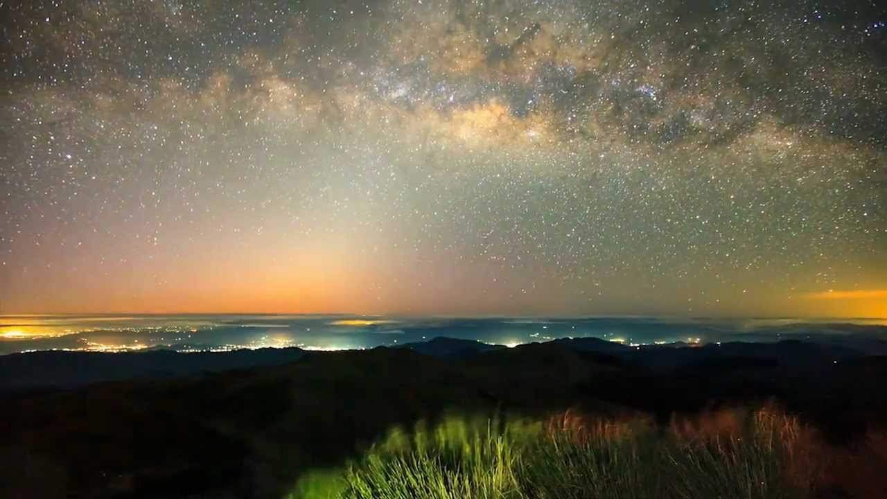
Care for some spectacular natural shows on a mountain? Then head on to Mt Pulag, a majestic mountain that rewards its visitors with a phenomenal sea of rolling clouds and a heart-stopping view of the Milky Way at dawn. It also features beautiful montane forests and dwarf bamboo slopes, completing an enchanting mountain-climbing experience. Mt. Pulag is so magical and magnificent, native tribes call it the “playground of the gods.”
Mt. Pulag is the Philippines’ third highest mountain, and Luzon’s highest, rising 2,922 above sea level. The peak converges the borders of 3 provinces: Benguet, Ifugao, and Nueva Vizcaya. Because of its high elevation, Mt. Pulag is super cold, dipping to sub-zero temperatures during the cold season. The chilly months of December, January, and February bring frost to the mountain, plus occasional mild flurries. August is the wettest month, with rain showers on the mountain.
Wildlife is abundant on Mt. Pulag. In fact, it’s one of the most diverse biodiverse parts of the country, complete with endangered mammals and 33 bird species. The mountain also has a documented 528 plant species.
You may choose from the 4 major trails to the summit. If you are coming from Benguet, you may take either the Tawangan, Akiki, or the Ambangeg trails. From Nueva Vizcaya, the only trail is Ambaguio.
Another attraction of Mt. Pulag is one of the cultural treasures of the Philippines: the Kabayan mummy burial caves. Here, the Ibaloi ethnic group bury their mummified dead. A large part of Mt. Pulag is still inhabitad by ethnic groups—apart from the Ibalois, there’s also the Kalanguya, Kankana-eys, Ifugaos, Ilocanos, and Karao.
Since this is about 10 hours from Manila, the entire adventurous tour of Mt. Pulag will take about 2 to 3 days. We’d recommend that you search for a packaged, organized tour for Mt. Pulag. Many of these exist for hiking in the Philippines.
How to get there:
- If you are commuting, head to Cubao or Pasay and take the bus to Baguio City. Rent a jeep to Ranger Station, or take the public bus in Dangwa, Baguio City (i.e. A-Liner), then ride the habal-habal to Ranger Stn.
- If you are driving a private vehicle, take the NLEX>SCTEX>TPLEX>Marcos Highway or Kennon Road>Baguio City, then take the road to Kabayan via Itogon. For 4×4 vehicles, it may be possible to head to to Ranger. Always check with DENR first.
Helpful articles and blog posts on hiking in the Philippines:
We only recommend writers and blogs that we read regularly and believe will deliver substantial value to our readers. The following is our top picks of articles we think are worth reading for you to get more information and a more extensive guide to hiking some of the mountains that we recommend:
- “Mt. Pulag via Ambangeg Trail” – by Ivan Henares from pinoymountaineer
- “Chasing the sunset: Mt. Balagbag” – from TINANICETOE
- “Pico de Loro | New Trail, Same Trials” – by Marxtermind
How Did We Do?
Is the article “Hiking: Top 12 mountains in the Philippines” useful? If so, please share and like this post, as it helps other travelers find information. Many thanks! You can follow us on Twitter or Facebook for further updates!